Draft 2055 MTP & Preferred Scenario - Archive
The Draft 2055 MTP
Draft 2055 MTP: Roadway Project List and Maps
Draft 2055 MTP: Roadway Project List
Draft 2055 MTP: Roadway By Horizon
Draft 2055 MTP: Roadway By Improvement Type
Bicycle & Pedestrian Maps
Draft 2055 MTP: Bicycle & Pedestrian Improvements By Facility Type
Draft 2055 MTP: Bicycle & Pedestrian Improvements By Mode
Draft 2055 MTP: Bicycle & Pedestrian Improvements By Tier
Transit Maps
Draft 2055 MTP: Transit Network
Upon completion of the Fiscal Constraint analysis of the Preferred Scenario, the above project list and subsequent maps were developed to reflect the fiscal constraint methodology recommended by the CAMPO governing bodies. At that point they became the Draft 2055 MTP.
The Preferred Scenario Phase began development in Summer 2025. Analysis and Public Engagement are ongoing.
What is the Preferred Scenario?
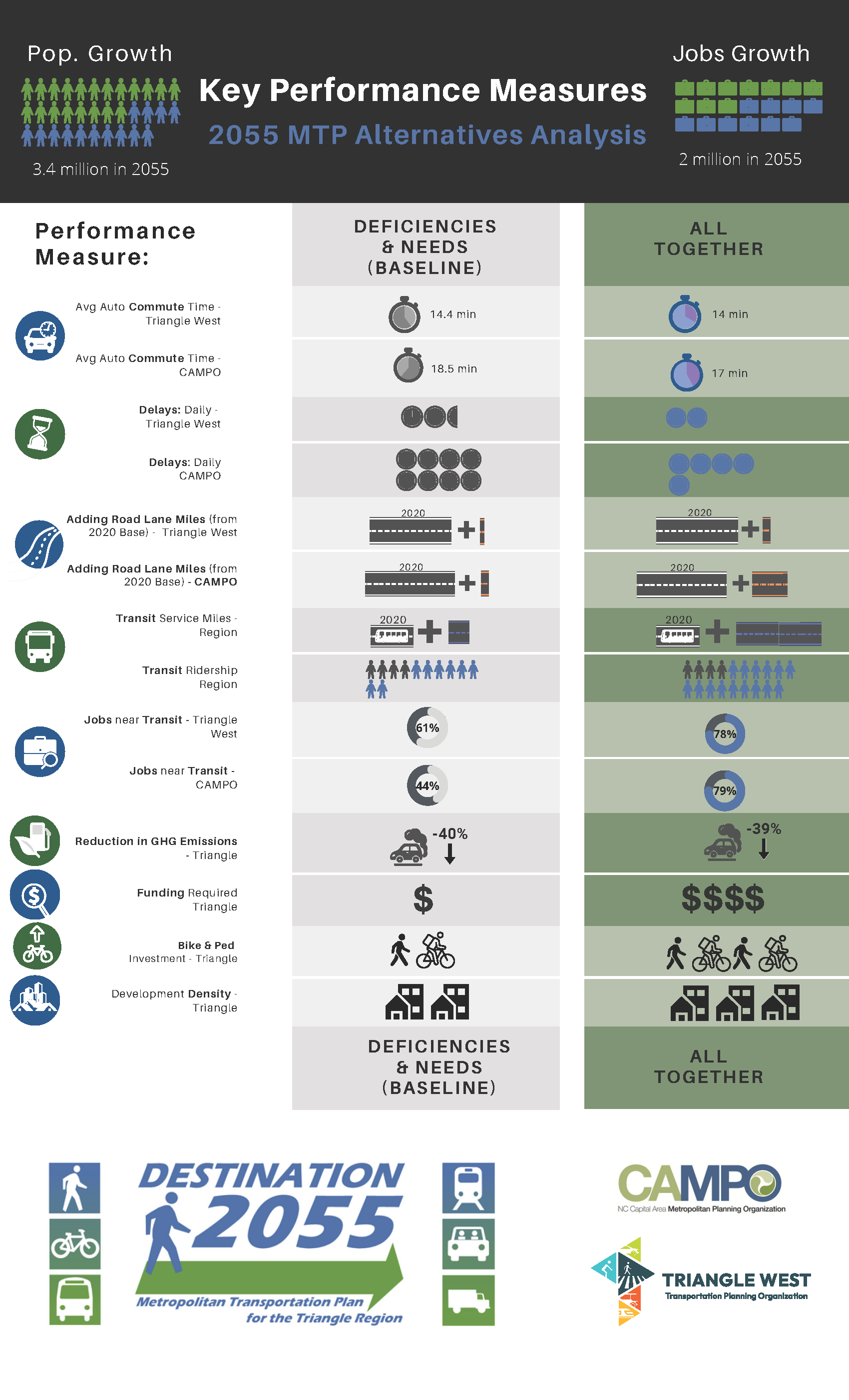
The Preferred Scenario (based upon the All Together scenario from the Alternative Scenario analysis) increases the intensity and mix of land uses at major employment hubs and travel corridors, and works to link our community to jobs through varied modes of transport. It increases biking and walking facilities and provides transit services in major commuting corridors and major activity centers. It assumes several future transportation funding changes on the state and local level, which means both housing affordability and transportation funding actions by a range of partners would be necessary. It also assumes that a larger proportion of residential and employment development occurs in the corridors served by bus, Bus Rapid Transit (BRT), regional rail, and bicycle and pedestrian facilities. This scenario includes the highest density with mixed use land development, which increases transit usage to reduce Vehicle Miles Traveled. It also has the highest funding level among the alternative scenarios that were compared.
Landmarks in Developing the Preferred Scenario
All Together Scenario - Vehicle Congestion - Daily Peak Period (2055)
In the spring of 2025, three Alternative Scenarios were developed and brought out to the community through a comprehensive public engagement effort. Of those alternatives the most robust in project development and funding was the "All Together" scenario. In June 2025, this scenario was selected by CAMPO's governing bodies to be the basis of the 2055 MTP "Preferred Scenario".
Preferred Scenario - Vehicle Congestion - Daily Peak Period (2055)
Over the next two months, CAMPO staff - working alongside staff from CPRC and Triangle West TPO - and in coordination with our local jurisdictional partners updated and refined the project lists across all modes associated with the original "All Together" scenario. The addition of some new projects and the refinement of previously existing projects in the Triangle Regional Model altered the way in which some aspects of the transportation network behaved within the thirty-year planning horizon. Updated mapping and public engagement materials were developed and a second public engagement effort was conducted to gather any additional feedback from staff, stakeholders and the general public.
Public Engagement
Public engagement activities of the Preferred Scenario analysis concluded on August 10, 2025. View the comments received here.
The following maps were developed prior to the fiscal constraint analysis, and represent the list of projects in the Preferred Scenario's impact on the efficacy of the tranpsortation network through 2055.
- Dot Density – Household Population and Employment
- Travel Time Forecast Isochrone Maps – AM Inbound
- Travel Time Forecast Isochrone Maps – PM Outbound
- Vehicle Congestion “Tomato” Maps - Combined CAMPO/Triangle TPO Region
- Vehicle Congestion “Tomato” Maps – Daily Peak Period (CAMPO Partner Jurisdictions)
- Angier (2020 Base Year | Angier (2055) Preferred
- Apex (2020) Base Year | Apex (2055) Preferred
- Archer Lodge (2020) Base Year | Archer Lodge (2055) Preferred
- Bunn (2020) Base Year | Bunn (2055) Preferred
- Butner (2020) Base Year | Butner (2055) Preferred
- Cary (2020) Base Year | Cary (2055) Preferred
- Clayton (2020) Base Year | Clayton (2055) Preferred
- Coats (2020) Base Year | Coats (2055) All Preferred
- Creedmoor (2020) Base Year | Creedmoor (2055) Preferred
- Franklinton (2020) Base Year | Franklinton (2055) All Together
- Fuquay-Varina (2020) Base Year | Fuquay-Varina (2055) Preferred
- Garner (2020) Base Year | Garner (2055) Preferred
- Holly Springs (2020) Base Year | Holly Springs (2055) Preferred
- Knightdale (2020) Base Year | Knightdale (2055) Preferred
- Lillington (2020) Base Year | Lillington (2055) Preferred
- Morrisville (2020) Base Year | Morrisville (2055) Preferred
- Raleigh (2020) Base Year | Raleigh (2055) Preferred
- Rolesville (2020) Base Year | Rolesville (2055) Preferred
- Wake Forest (2020) Base Year | Wake Forest (2055) Preferred
- Wendell (2020) Base Year | Wendell (2055) Preferred
- Youngsville (2020) Base Year | Youngsville (2055) Preferred
- Zebulon (2020) Base Year | Zebulon (2055) Preferred
Visit the Maps & Data page for additional information on the analyses.